


Mapa Turystyczna

Περιγραφή του Mapa Turystyczna
Ο Τουριστικός Χάρτης είναι μια εφαρμογή που δημιουργήθηκε για να διευκολύνει τον προγραμματισμό εκδρομών στο βουνό και να βοηθήσει στην πλοήγηση στη διαδρομή.
Σχεδιασμός διαδρομής
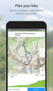
Η κύρια λειτουργία είναι η δυνατότητα σχεδιασμού διαδρομών κατά μήκος μονοπατιών πεζοπορίας στα βουνά και τους πρόποδες. Η εφαρμογή υπολογίζει εύκολα και γρήγορα τη διαδρομή, εμφανίζει την πορεία της στο χάρτη, δείχνει το μήκος και τον εκτιμώμενο χρόνο διέλευσης, λεπτομερή διαδρομή και προφίλ υψομέτρου. Υποδεικνύει επίσης την τρέχουσα τοποθεσία του χρήστη.
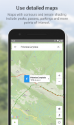
Ένας λεπτομερής τουριστικός χάρτης, εκτός από τις γραμμές περιγράμματος και τη σκίαση του εδάφους, περιλαμβάνει επίσης κορυφές, περάσματα, χώρους στάθμευσης και άλλα ορόσημα. Στην έκδοση Premium, μπορείτε να κατεβάσετε χάρτες των περιοχών που αναφέρονται παρακάτω και να τους χρησιμοποιήσετε εκτός σύνδεσης.
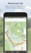
Εγγραφή διαδρομής
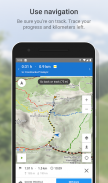
Το δεύτερο σημαντικό χαρακτηριστικό είναι η δυνατότητα καταγραφής διαδρομών. Η πορεία της διαδρομής στον χάρτη, το μήκος και η διάρκειά της αποθηκεύονται.
Συγχρονισμός διαδρομών με τον ιστότοπο
Τόσο οι προγραμματισμένες διαδρομές όσο και οι καταγεγραμμένες διαδρομές αποθηκεύονται στον λογαριασμό χρήστη. Χάρη στον συγχρονισμό, είναι επίσης διαθέσιμα στον ιστότοπο mapa-turystyczna.pl, όπου μπορείτε εύκολα να δείτε λεπτομερείς παραμέτρους.
Ενδιαφέροντα μέρη
Επιπλέον, η εφαρμογή εμφανίζει πληροφορίες για ενδιαφέροντα μέρη: φωτογραφίες και κριτικές χρηστών με βάση δεδομένα από τον ιστότοπο mapa-turystyczna.pl.
Αναλυτικές λειτουργίες:
- Αναζήτηση διαδρομής με βάση δεδομένα σημεία. τα σημεία μπορούν να επιλεγούν από τον χάρτη ή να βρεθούν στη μηχανή αναζήτησης,
- έξυπνες συμβουλές στον εντοπισμό θέσεων λαμβάνοντας υπόψη το μέρος που βρίσκεται πιο κοντά στην τρέχουσα τοποθεσία και τα πιο δημοφιλή μέρη,
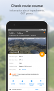
- εμφάνιση της διαδρομής που αναζητήθηκε στον χάρτη και εμφάνιση του μήκους, του εκτιμώμενου χρόνου διέλευσης, της λεπτομερούς διαδρομής (τόποι και μεμονωμένα μονοπάτια στη διαδρομή) και του προφίλ υψομέτρου,
- μηνύματα σχετικά με τα εμπόδια στα μονοπάτια,
- GOT βαθμολογία για τη διαδρομή που βρέθηκε,
- εμφάνιση της τρέχουσας τοποθεσίας στον χάρτη,
- πυξίδα,
- καταγραφή διαδρομής. η απόσταση που διανύθηκε και ο χρόνος που έχει παρέλθει από την έναρξη εμφανίζονται σε συνεχή βάση,
- λίστα καταγεγραμμένων διαδρομών,
- αναζήτηση θέσεων και εμφάνισή τους στον χάρτη,
- εμφάνιση πληροφοριών σχετικά με τα μέρη που βρέθηκαν: φωτογραφίες και κριτικές χρηστών με βάση δεδομένα από τον ιστότοπο mapa-turystyczna.pl,
- πλοήγηση σε μια διαδρομή που αναζητήθηκε,
- ένα στρώμα λεπτομερών τουριστικών χαρτών, επίσης διαθέσιμο για λήψη και χρήση εκτός σύνδεσης.
Το δίκτυο των μονοπατιών περιλαμβάνει π.χ. περιοχές:
* Μπέσκιντς
** Μακόφσκι Μπέσκιντς
** Μικροί Μπέσκιντς
** Χαμηλά Beskids
** Beskid Sądecki
** Σιλεσιανοί Μπέσκιντς
** Σιλεσιο-Μοραβίας Μπεσκίντ
** Beskid Wyspowy
** Beskid Żywiecki
** Bieszczady
** Ζεστό
* Σουδέτες
** Όρη Bardzkie
** Όρη Bystrzyckie
** Eagle Mountains
** Όρη Jizera
** Όρη Kaczawskie
** Πέτρινα Βουνά
** Όρη Opava
** Βουνά κουκουβάγιας
** Επιτραπέζια βουνά
** Τα βουνά Walbrzych
** Χρυσά Βουνά
** Λευκά Όρη
** Γιγαντιαία Βουνά
** Κοιλάδα Jeleniogórska
** Ορεινός όγκος Śnieżnik
** Rudawy Janowickie
* Πρόποδες των Σουδητών
** Izerskie Foothills
** Πρόποδες Kaczawskie
* Sudeckie Foothills
** Ορεινός όγκος Ślęża
** Πρόποδες του Paczkowskie
** Η πεδιάδα Świdnicka
** Λόφοι Niemczańsko-Strzelińskie
** Strzegom Hills
* Πρόποδες των Μπεσκήδων
** Οι πρόποδες Ciężkowickie
** Πρόποδες Przemyśl
** Rożnów Foothills
** Strzyżów Foothills
** Dynów Foothills
** Wieliczka Foothills
** Wiśnickie Foothills
* Το υπόλοιπο
** Νησί Wolin
** Όρη Swietokrzyskie
** Οροπέδιο Suchedniowski
** Το Δάσος Καμπίνου
** Jura Krakowsko-Częstochowska
** Πύλη της Κρακοβίας
** Πιενίνι
** Πρόποδες των βουνών Τάτρα
** Τμήματα Orava
** Όρη Τάτρα
* Σλοβακία
** Βουνά Choč
** Skoruszyńskie Wierchy
** Όρη Kysucky
** Magura Orawska
** Spis Magura
** Μικρή Φάτρα
** Χαμηλά Τάτρα
** Σλοβακικός Παράδεισος
** Μεγάλη Φάτρα
** Υψηλά Τάτρα
Η εφαρμογή είναι δωρεάν. Πρέπει να είστε συνδεδεμένοι στο Διαδίκτυο για να σχεδιάσετε διαδρομές και να δείτε πληροφορίες σχετικά με μέρη. Η λήψη και η πλοήγηση τουριστικού χάρτη είναι διαθέσιμα στην επιλογή Premium (με πληρωμή).
Mapa Turystyczna - Έκδοση 1.14.1
(14-04-2025)
Mapa Turystyczna - Πληροφορίες APK
Έκδοση APK: 1.14.1Πακέτο: pl.mapa_turystyczna.appΤελευταία έκδοση του Mapa Turystyczna
Άλλες εκδόσεις


Εφαρμογές στην ίδια κατηγορία

Μπορεί επίσης να σου αρέσουν...


